Galileo Group has developed proprietary software to process and analyze large amount of AISA hyperspectral data in a timely manner, which can be a “bottleneck” for many other imaging firms.
With our software and high-end computing facilities, our required turnaround time to delivery is minimal relative to other competitors, typically just days even for very large project areas, compared with weeks for most others. Extremely rapid processing and analysis is particularly important in certain applications such as emergency response, natural disasters and environmental assessment as well as military and other scenarios where imagery must be provided without delay.
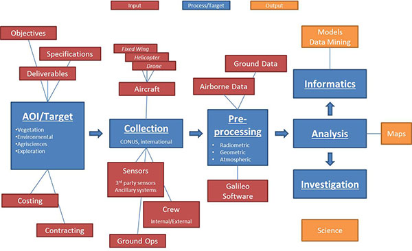
Galileo Group’s standard hyperspectral imagery products are all radiometrically calibrated and geo-referenced, with optional delivery of image mosaic and individual flight lines. The detail processing steps include:
- Raw hyperspectral data are collected with optimal spatial and spectral resolution.
- Raw images are radiometrically calibrated to spectral reflectance values with bad pixel removal when necessary.
- With synchronized IMU and GPS navigation data, all pixels are accurately geo-referenced. DEM data are supported when higher accuracy is required.
- Individual flight lines can be mosaiced with optimal cut-lines. Cross-track illumination variations are corrected when necessary.
- Atmospheric correction and reflectance calibration are optional.
- Customized map and classification products.
Custom Hyperspectral Imagery
For custom missions with your special application, let our mission planning specialists work with you to develop an efficient and economical aerial profile. We handle the entire mission turn-key style, so that all aircraft, planning and operations are included with the bid. Our personnel are experienced in domestic and international flight operations.
Hyperspectral Imagery Archive
Galileo Group Inc. has collected a variety of unique hyperspectral imagery with meter to sub-meter resolution in VNIR or SWIR ranges. All data are radiometrically calibrated and geo-referenced. Urban, wetland, coastal, crop, forest and desert data sets are available. Multi-temporal datasets are also available for change detection applications. Spectral/spatial resolution settings vary by target class. Raw data is available upon request.

